Part 1: Dating Clason State Road Maps 1923-1931, an Overview
Introduction
Those attempting to date Clason state road maps issued from 1923 to 1931 are presented with unusual challenges. Unlike Rand McNally and Gousha, the Clason Map Company (CMCo) typically did not even place codes on its products during this period. A systematic review of the individual maps contained in the Clason Touring Atlases, which have now been dated (See Liedholm and Greaves, (fix this URL) Dating Clason Touring Atlases), revealed that the road legends and other map symbols varied over the years. This was particularly true of the kinds and number of road types portrayed in the legend. For example, one “typical” (key) road type description tended to dominate each year (see below, “Typical “ Road Legends by Year) ), and some might be tempted to use this as a crude dating device for the individual state maps. However, there were often numerous state variations in these legends within any one year. In the 1925 Touring Atlas alone, for example, there were 17 different state road legends. Thus, if these state maps are to be more precisely dated, a more detailed state by state, year by year listing of the key map symbols is needed. The (fix this URL) Clason State Map Dating Guide, which was developed by Mark Greaves and Carl Liedholm from the maps in the Touring Atlases, represents an initial attempt at providing such a document.
The Clason State Map Dating Guide
The (Fix this URL) Clason State Map Dating Guide, is organized by state and lists the map features such as the title, sub-title, road legends, and official highway markers year by year. One should use these features on the state map to delineate the year. In the Indiana map below, for example, the title (A) is “Midget Mileage Map”, the sub-title (B) is “Showing – Paved Roads – Road Distances” the Road Legend (C) lists “Paved and Hard Surfaced” and “Other Thoroughfares,” and the official highway marker (D) is “Route 27.” A perusal of the (fix this URL) Guide indicates that an Indiana map with these characteristics would be dated as 1924 (1924a was an early variant and 1924b, if listed, was a later variant, possibly early 1925; there was also a later variant of 1926, labeled 1926c). Midget maps, which were typically identical to the regular maps except in size, were produced in several years along with the regular maps. The Clason maps became more standardized in 1928, so after that date there were fewer variations in the map features by state and year. If there are no changes in the map features for a particular year, this will be indicated in the second column of the guide (e.g. same as 1928). A more precise dating of these later maps can only be obtained by a careful scrutiny of the yearly changes in the road networks of these particular states. In Michigan, for example, the route from St. Johns to Owosso was just an all weather road on the 1928 map, but became a paved road on the map of 1929; on the 1930 map, U.S. 27 north of St. Johns was paved only to Mt. Pleasant, but on that of 1931 paving extended to Clare. Similar information relating to the other state maps during this period will hopefully be generated in the not too distant future. Finally, it is important to recognize that the guide is based on the maps contained in the Clason Touring Atlases. Consequently, there are likely to be versions of the state maps that do not appear in the Touring Atlases and thus that are not listed in this Guide. The Guide should be viewed as preliminary and as a work in progress, so any missing versions, corrections, or comments are most welcome. Contact: Carl liedholm liedhol1@msu.edu

|
Date |
Examples of Road Legends with Their Distinctive Features |
|
|
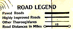
Key: "Highly Improved Roads" |
|
1924 |
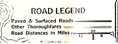
Key : "Paved and [Hard] Surfaced Roads" or, if you see only two road classifications |
|
1925 |
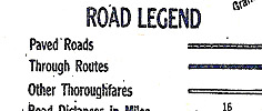
Key: "Through Routes" or "Best Roads" |
|
1926 |
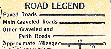
Key: Graveled Roads (or any mention of gravel), plus no roads printed in red |
|
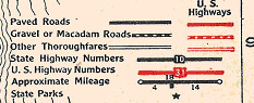
1927 |
Key: Red roads (Red U.S. Highways appear for the first time and in all subsequent years) along with a mention of gravel and/or macadam roads |
|
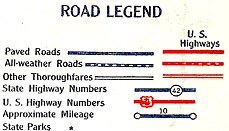
1928 |
Key: All-Weather Roads, plus (Blue) printing |
|
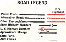
1929 -1931 |
Key: All-Weather Roads, plus (Black) printing |
This site is designed to provide information on Clason road maps and atlases. New information will be posted as it is obtained. Corrections, additions, and comments are welcome. Please contact Carl Liedholm